Overview
A low off the Mid-Atlantic interacting with a High Pressure advancing Northeast will set up a nice gradient of North to Northeast winds targeting the Florida coast. It’s not a major storm, so we’re not expecting huge numbers- but it should get in to the fun-sized range this weekend. Winds may not entirely cooperate, but we may see some decent-good conditions at upcoast spots.
Weather Details
A weak cold front has made it’s way through Florida with a northerly flow filling in it’s wake. Look for winds to be Northeast in the 10-15mph range, and keep a northerly tilt through Saturday before slacking overnight. Eventually we settle in to a calm ESE flow on Sunday before another stronger front approaches Monday-Tuesday. Pretty good chance we’ll see something on that front, maybe even down south.
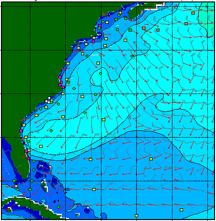
For this swell, we’re looking at a good set up for Florida. It’s a shorter period swell, only about 8 seconds or so. That’ll set us up for lots of peaky short-interval waves. It looks to peak on Saturday night or Sunday Morning in the 6′ range out of the ENE. There’s a good amount of NE energy in that ENE, so I wouldn’t doubt that some of the Palm Beaches pick some of this swell up. The SWAN model shows that below.
The next front is bringing a big northerly blow. Swell should build up to 7 feet at 7 seconds with a straight north tilt. Timing the wind to get some of the swell with NW’s wind before it comes hard north could provide difficult. Broward and Miami should monitor this swell since it could thread the needle with this sort of direction.
Florida Surf Forecast
(North of Palm Beach to Central Florida)
Saturday: North/Northeast wind at 10-15 mph. Swell building to chest high at top spots by dark, smaller south.
Sunday: Swell holding at chest+ during the morning with calm winds. Biggest towards Central Florida, smaller down in to the Palm Beaches. Flat down south. Wind should come up out of the ESE as day warms up.
Monday: Leftovers with increasing SE winds ahead of the next front. Chance for some SE windchop down south, especially.
Tuesday: Front start moving down the state. Swell being created.
Wednesday: North windswell shows up in the head high range at top spots. Timing the front with the wind will be the trick. Once, the blow starts up, it should stay windy for the future.