The tropics started heating up early this year! As forecast, Tropical Storm Bonnie formed last weekend and threw a fun little swell to Florida for the Memorial Day Weekend. The remnants of Bonnie have re-generated to Tropical Depression Bonnie, and are located about 25 miles east-southeast of Cape Hatteras, North Carolina. We aren’t expecting to see anything further from her, however. Overall, the weekend looks pretty small, with only marginal east tradeswell up above the Bahama bank with onshores.
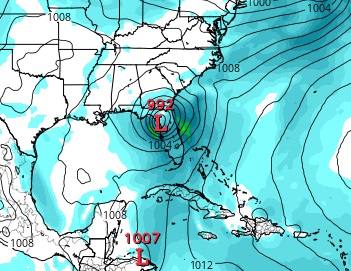
What we’re really watching…A broad area of low pressure is expected to organize over the Yucatan or the southern Gulf of Mexico by late in the weekend. This low is forecast to strengthen while moving Northeast before crossing the Florida peninsula sometime around Tuesday. Right now, we’re looking for a strong southerly blow on Monday/Tuesday, followed by a switch to the SW and then West. Once the storm enters the Atlantic waters, it’s possible that we’ll see a wrap-around North swell. Models are in pretty good agreement that we’ll see a South wind event, so we’re confident that we’ll get some surf early next week. We’ll know more about the size and quality as forecasts become actuals…
Best bet?
Get ready for Hurricane Season 2016!