Overview
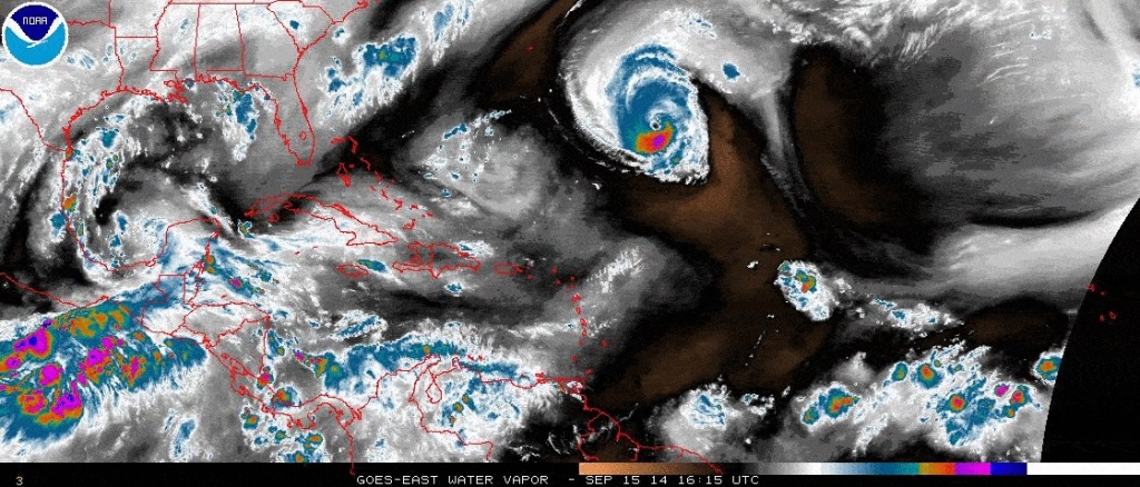
Our fifth named storm of the 2014 Atlantic Basin Tropical Season is chugging along nicely in the Western Atlantic. The storm is nearing Category 3 status, as conditions have been favorable for development- and will continue to be conducive for continued strengthening. Luckily, the storm poses no threat to land…except for high surf along exposed coasts.
Hurricane Edouard Storm Details
As you can tell from the below satellite imagery, Hurricane Edouard has a defined center of circulation and distinctive eye. There is strong convection flaring around the center and outflow looks healthy. Conditions will remain favorable for the storm to intensify for the next day or so, before reaching cooler water and considerable sheer. The storm will then increase in forward speed, weaken and head out to the Northeast thereby ending all swell generating potential for the East Coast from this storm.

Edouard’s Swell Details
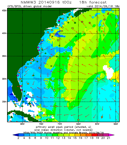
Hurricane Edouard is a great storm for surf on the East Coast. It’s also a terrible storm for surf on the East Coast. A storm of this size, strength, and duration puts down a significant amount of swell- and not just significant relative to the Atlantic. This storm is moving toward our beaches with giant seas for a prolonged period of time and is also over a thousand miles away…just like rival storms in the Pacific or Indian Ocean. The problem with this scenario is that most of our beaches aren’t equipped to handle a swell of this magnitude. Yes, there will be waves. And yes, it will be big. It will even be good winds for most places! The biggest problem will be closeouts due to the long period swell. Tons of ’em! The below map forecasts the arrival of 15/16 second swell late on Tuesday. To surf a swell like this, you’ll need to know the spots that can handle the juice!
Florida Forecast
(North of Palm Beach)
For Florida, swell from Edouard will arrive late Tuesday in to Wednesday. Look for the swell to build considerably during the day on Wednesday before peaking late in the day/evening. We’ll see waves pinging the buoys at nearly 18 seconds as it starts to fill in, but the biggest stuff will probably be 5-6 feet at 15/16 seconds. If you know Central America, you know that a swell that size would get the points and reefs going- It’s that kind of swell. As Thursday dawns, look for solid leftovers fading in to Friday. The weekend also looks interesting with an approaching cold front with potential for swell generation!
Tuesday: Swell arrives late. Watch the East Canaveral Buoy for small, long period (16+ sec) swell. If it shows early morning on that buoy, you might have a shot for an afternoon session.
Wednesday: Swell arriving from the East in the head to well overhead range. Biggest in the afternoon. Winds will be straight offshore and light. Big, long lines. Mostly shutting down at your average beachbreak. Find some place with a great bottom or some rock. Smaller further south to completely flat in the Palm Beaches.
Thursday: Fading swell in the shoulder to head high+ range with light offshore winds in the morning, turning more northerly.
Friday: Edouard’s swell fades to near flat.
New York/New Jersey Forecast
(Northern Jersey and Long Island)
Once again, the Uns0und Pro will have sick waves. Edourd’s swell will reach the beaches of New Jersey and Long Island late Tuesday in to Wednesday. Given the current forecast, we’re looking at the bulk of this swell arriving on Thursday- which is great timing since it coincides with a passing cold front and northerly, offshore winds for Day 1 of competition. We’r looking at easily overhead waves with straight offshores on Long Island. Look for that swell to hold a bit in to Friday before fading out on Saturday.
Tuesday: Edouardo’s swell should start late afternoon on Tuesday. Check Buoy 44066 for long period swell on early Tuesday morning to see what you might be seeing during the day, It shouldn’t be much, but might get rideable.
Wednesday: Edouardo swell arriving with passing and weakening cold front. Chest to overhead with northerly wind. Watch the front for possible wind shift to west earlier than forecast.
Thursday: What a day. Looks like well overhead Southeast swell with offshore winds in the wake of a cold front. Perfect day for the Volcom Uns0und Pro.
Friday: Swell is forecast to fade to maybe waist high or so, but watch this swell to peak on the buoys south of LI to see how much oomph is really left in the swell train. Eduardo might strengthen more than forecast, or stay on a more northerly path creating additional swell.
